Tuesday, November 30, 2010

FLAGLER'S DREAM

St. Augustine, FL 29º53.153N | 81º18.319W


Ponce de Leon Hall under an unedited blue sky.      ©2010 Tammy Kennon
We took a tour of Flagler College today, where our friend Barb teaches. It did not fit any model I had in my head for "college campus," so I guess I learned something at school today.

The buildings here were the brainchild of Henry Flagler, who built them in 1888 as an exclusive resort for the ultra-wealthy. If you've never heard of Henry Flagler, you should read about him. Quite the colorful character and in part responsible for bringing civilization to Florida, for better or worse, depending on your philosophy.

Entrance gate to Flagler.
I can say this: The hotel he built in 1888 exceeds today's standards. I guess we just don't build things like this any more.

Ceiling in the student dining hall (!).
As I walked around gaping at the opulence of Ponce de Leon Hall, formerly the main hotel building, I wondered if the students have an appreciation for their surroundings, the gold leaf, the mammoth Tiffany (yes, that Tiffany) windows, the Greek revival columns and caryatids. I wondered if we learn better in a beautiful environment or do our otherwise bland, institutional settings offer fewer distractions?

Columns in the dining hall, formerly the ballroom.
I also wondered what it must have been like to be a pampered guest in the hotel, although at the current equivalent of a cool quarter of a million for the season, I'm quite sure I would never have known.

It's not hard to imagine my 1800s self rowing ashore in a derelict boat wearing foulies and inappropriate footwear, just like I did today. I'm guessing I would not have gotten beyond...

...here.
St. Augustine, FL 29º53.153N | 81º18.319W


Tiffany windows at Flagler College.  ©2010 Tammy Kennon
White onyx clock in the ladies lounge.

Monday, November 29, 2010

RECONNECTING

St. Augustine, FL 29º53.153N | 81º18.319W


Unedited blue of a St. Augustine sky.     ©2010 Tammy Kennon
St. Augustine offers a lot of reasons to dawdle: the enchanting Spanish architecture, the cobblestone streets lined with palm trees, the many threads of history woven throughout town, the art galleries, the music, the restaurants. And what about the fresh bread bakery and the handmade chocolate shop(!) or the marina in the heart of downtown with mooring balls for only $20 a day.

All reason enough but not why we have chosen to stay a week here. For the last four years the focus of our lives has been disconnecting, a necessary step in following this large dream, but I guess it should come as no surprise that we have been feeling disconnected.

This is a much needed chance to reconnect with some old friends who moved away from the Outer Banks with their toddler -- now a 10-year-old.


You know the kind of friends where you can finish the sentence left hanging five years ago? The friendship that time lapses cannot weaken, a comfortable camaraderie that doesn't have to start with a background sketch or that "where are you from" question that is now so difficult to answer.

Chip, Barb, Seth and David.
Just the five of us at ease. Meandering around town. Making pizza at home. Laughing -- a lot.

St. Augustine, FL 29º53.153N | 81º18.319W


Not a painting. Real. 208 feet tall.  ©2010 Tammy Kennon
A Tiffany window at Flagler College.

Sunday, November 28, 2010

SKIDDING AMONG FRIENDS

Fernandina Beach, FL 30º40.229N | 81º28.172W

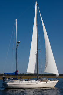
Jessie Marie sneaking up on us.   Photo by Chip
The flock is heading south again. After a short respite -- and a beautiful weather window -- in St. Mary's, we're all migrating, hoping to shake off cold weather for good.

We left the mooring field in Fernandina at 7:30 with our friends on Kajon after much deliberation about what the weather might hold, finally deciding whatever it was, we would manage. Our goal was to make the 62-mile trudge to St. Augustine, a long slog, to a harbor we didn't want to enter after dark.

The weather was kind if cold, and the water delivered friendly faces along the way.

"Cara Mia, Cara Mia, this is Jessie Marie."

"Where are you?" Chip asked.

"Right behind you!"

Sure enough, there they were, our Nova Scotian friends Karen and Dale, tailing us, although not for long. A bridge in Sisters Creek that opens on request bunched five of us sailboats together just as we were about to enter the St. John's River.
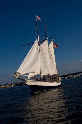
Photo by Chip
Jessie Marie came flying around us looking fabulous, just as I was saying, "Hey, there's a lot of current here and the GPS isn't showing me the route." Two things that together were making me a little nervous, since I was at the helm. At this point we were the last of the five boats, all close together, following this pink line:


I was about to pass a very tiny sailboat in front of me as we approached the pink arrow. Looking ahead to the first boat in the group, I did a double, triple, quaruple take. The first boat suddenly started skittering sideways off to starboard -- fast. Behind it, Kajon took off like someone plopped it on a conveyor belt, shooting them way off to the right as Jessie Marie came up behind them.

The current was barreling, practically roaring around that point of land by the arrow, and slamming the boats sideways as we were entering the mouth of Pablo Creek.

I realized at this point (clever me) that in a few minutes, I would be thrown on the conveyor belt -- and I had a small sailboat to my right, exactly where the conveyor belt would take me. My fear was that I would block the current for them meaning I would fly to the right, they would not, and, well, you get the idea.

I threw the throttle in neutral and then in reverse, trying to slow down enough to let the small boat clear my bow before I hit the current -- and them. Reverse, reverse, throttling up, up, up.

Chip tried to hail the small boat on 16, "Get going, get going!"

Cara Mia worked with me beautifully. We slowed enough to let the other boat get just ahead, and, since our forward motion had slowed and our boat is heavy, we didn't get thrown as far to starboard as the others. I also had the benefit of knowing what was coming and held to port as we entered the current.

Whew.
Debi on Kajon snapped this pic just as we were entering the roar.
The rest of the day passed with less drama. As we neared St. Augustine, we passed our British friends, Barney and Di, on Sea Gal, sailing as big as you please, just as if they were on the high seas. I swear they were sipping tea out of dainty China cups in the cockpit.

Sea Gal.    photo by Chip
Inspired, we unfurled the jib and practically flew into St. Augustine at 8.5 knots, entering the harbor at St. Augustine at dusk. We took a wrong turn, then a U-turn, then had to wait for the 4:30 opening of the Bridge of Lions -- and then had to wait for the boats coming through with the current (right of way).  But after 9 1/2 hours on the water, we picked up our second mooring ball, not quite as professionally, and settled, exhausted, resting on the knowledge that we were staying in St. Augustine for a whole week on the peace of a mooring ball.

Peaceful like in Fernandina? We'll see.

St. Augustine, FL 29º53.153N | 81º18.319W


Freedom wings through the Bridge of Lions...

...followed by their mateys on the Black Raven.

Saturday, November 27, 2010

WHAT A DRAG

St. Mary's, GA 30º43.097N | 81º33.101W


Mooring ball and pendant (rope with loop on end
hooked to anchored ball).
Our day started a little rough in St. Mary's when the anchor chain jammed in the windlass. Fortunately the anchor had not released from the bottom, so we had time to figure out what the heck to do without the boat moving. After considering a lot of sketchy ideas for unjamming it, we successfully snubbed up the chain and used the slack to pull it backwards, freeing it with some hearty yanking.

The 1-1/2 hour trip across the water to Fernandina Beach was uneventful, but the wind was picking up when we pulled up to our mooring ball, while at the same time the tide was running full on. 

A mooring ball is a big anchored ball with a pendant you attach to your boat. Moorings are drilled into the bottom, so theoretically, in ideal conditions, mooring is safe and secure, free of the worries of potentially dragging anchor.

To successfully grab a mooring a quick series of things has to happen: The helmsperson pulls up next to a ball at water level that can't be seen from the helm, while the person on the bow snags the pendant with the boat hook. The boat must stop long enough for the person on the bow to grab the pendant off the boat hook, run a line through the pendant loop and snug it down before the boat starts moving again. If anyone falters, things go goofy -- fast. The whole procedure reminds me a little of calf roping, especially when you tie the line off and raise your hands in victory.

I am pleased and shocked to report that we accomplished this like professionals. Chip drove up to the ball and stopped. I picked up the pendant and threaded it effortlessly. The judges gave us an 8.9.

However, we were not to be drama-free. The increasing wind was running counter to that roaring current, sending the boats all willy nilly. Ideally a mooring ball is out in front of the boat with the boat pulling back on it. However, in this instance most of the boats were running over the balls, hitting them sideways, sometimes pulling them all the way under the keel and popping them up on the other side, wreaking havoc on nerves and bottom paint.

Since just about everyone was on deck fretting, we all watched as this happened:


The strong current had caused the small boat in the middle to drag its anchor, nearly careening into the near boat before heading straight at the catamaran while we all watched, unable to do anything other than radio the marina for help (and take pictures).


The captain of the catamaran charged over in his dinghy to push the little boat back -- and right upwind of us.

After about 20 tense minutes, the authorities arrived with (apparently) the owner of the derelict boat.


The county boat held the sailboat in place while the owner pulled up two very tiny anchors with equally tiny -- and very short lines before the offending boat was whisked away.


So much for the quiet safety of mooring. Oh, and welcome to Florida!

Fernandina Beach, FL 30º40.229N | 81º28.172W

Our neighbor, Joe, ferried Chip to shore for a shower and a beer...
...while I stayed home and cooked pizza...
...as the sun set on a now-calm, if not entirely picturesque, Fernandina Beach.

Friday, November 26, 2010

INTO THE MASTS

Cumberland Island, GA 30º45.924N | 81º28.364W


Anchorage at the south end of Cumberland Island.
After three nights alone on the water, we decided to mix it up on land with lots of people. Destination: St. Mary's, Georgia. Tuesday morning we sailed into the masts.

St. Mary's anchorage in the distance.
People who travel on boats have many things in common, but on holidays, the most important is that we've all left home, family and friends behind. The kind and generous folks of St. Mary's took us all under their turkey wing, more than 100 boats, and fed us, drove us to the supermarket, the laundromat, the liquor store and the library.

For Cruisers Thanksgiving dinner, they provided turkey and ham; the cruisers brought the rest.

We found some other kids on the circuit. "Kids" now means younger than 60. You've gotta love that.

Diane & Barney from England aboard Sea Gal,
Karen & Dale from Nova Scotia aboard Jessie Marie.
Anna & Hakan from Sweden aboard Unicorn.
In my long and fortunate 50 years, I have never found it hard to find things to be thankful for, but this year the list runs over. The much more difficult task will be my Christmas list, because I can't think of anything more that I need.

Thanksgiving's foggy start.

St. Mary's, GA 30º43.097N | 81º33.101W


The dinghy pile-up in St. Mary's.
Hungry cruisers wait in line.
Sun sets on St. Mary's.
Cara Mia, happy among friends.        ©2010 Tammy Kennon

Tuesday, November 23, 2010

BEAUTY WITHOUT WORDS

Brickhill River, GA 30º51.832N | 81º28.368W


Brickhill River, Cumberland Island, GA.
Cumberland Island, Georgia, is the largest of the Sea Islands, the barrier islands along the Atlantic Coast from South Carolina to Florida. It is 17.5 miles long, 36,415 acres of marsh, mudflats and tidal creeks. The island is covered by a dense forest of live oaks hung with Spanish moss and populated by wild horses, armadillos, turkeys and white-tailed deer.

Over the centuries Cumberland Island has been inhabited by the Timucua, the Spanish, the English, the Greene family and the Carnegies. It has been raided by pirates and occupied by British troops, its trees harvested to build ships, its land tilled to grow cotton and its beauty used to entertain the powerful and the wealthy.

In 1969 the island was designated a National Seashore and today is mostly unpopulated.

These cold facts of history tell you nothing about the experience of Cumberland Island. I'm not sure prose or poetry can either. The natural beauty of this island borders on the surreal. These photos are my best offering.

Live oak canopy hung with Spanish moss.    ©Tammy Kennon
Palmettos fanning underneath the live oaks.  ©Tammy Kennon
Wild poser.     ©Tammy Kennon
Much of the island is covered by a live oak ceiling.   ©Tammy Kennon
Seemingly endless beach with white powdery sand.
©Tammy Kennon
Dungeness mansion, built in 1803 by Catherine Greene, burned to the ground in the mid-1800s.
Rebuilt by Thomas Carnegie in 1881, it burned again in 1945.

©Tammy Kennon
©Tammy Kennon
Cumberland Island, GA 30º45.924N | 81º28.364W

©Tammy Kennon
©Tammy Kennon

Monday, November 22, 2010

NOT ONE SINGLE TIME

Darien River, GA 31º23.046N | 81º20.043W


We humans love to push nature around, scraping it right down to the bedrock in order to pile up sticks and bricks and steel to cover ourselves. Then as an afterthought, we spread nature like peanut butter around the edges of our buildings, in little squares and rectangles, in pots and barrels, on porches and balconies.

We say silly things like "wildlife management" and "climate controlled."

We stand shoulder to shoulder on our steel girders, waving our arms, believing ourselves large and victorious.

This morning I opened the companionway to see this.


I was confused at why the sun looked so pale and exasperated when I realized it was sinking.

In 50 years, some 600+ times in my life, the full moon has set at sunrise and not one time, not a single time had I seen it before today.

Brickhill River, GA 30º51.832N | 81º28.368W


An eagle perched atop an ICW marker.
St. Simon Sound