

Georgetown, SC 33º21.664N | 79º16.822W
I am not surprised we ran aground today. I am surprised at where.
The waterway guidebook states that tides and currents become more extreme as you head south, so as we plan our route each day, we note the high and low tide information at the points along our path.
It's a complicated formula to figure out how to apply that information to real movement. A favorable tide for the beginning of a trip often means an unfavorable one somewhere down the way.
Basically, I think we're failing Tides 101. In all our studies, we did not realize that we are in a phase of epic tide swings because of the time of year and the moon phase. Sigh.
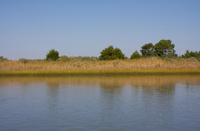
Our goal for the day was to get within range of Charleston, as close as possible to make tomorrow's passage short. The path took us through some lean, desolate terrain that was beautiful in a way reminiscent of my desert home: lean, low profile, subtle, and, as it turns out, low on water!
We flew out of Georgetown on high tide, making great time down the Waccamah River and into the ICW.
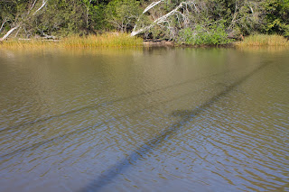
I don't know why it works this way, but every time my shift comes up at the helm, we enter treacherously shallow water. Bad luck on my part? Clever planning on Chip's part? This photo makes me think the latter:

My first shift was a pass through what I thought at the time was shallow water, running from 7 to 9 feet. Our depth meters are around 3 feet above the bottom of our keel. The alarm goes off at 3 feet, 6 inches.
Our general policy is to barrel along at full throttle until the meters drop below 10, then we throttle back some until it gets to 8. Until today, everything below 8 was terrifying.
So in that stretch of 7 to 9 feet, I had to plod along at about 4 knots in shallows stance: eyes shifting like a crazy person between the two meters, one hand on the wheel, one on the throttle, poised to go into grounding action. To state the obvious, it is tense and grueling.
During these times, our policy is to have the person off watch in the cockpit spotting marks, keeping an eye out for traffic, handling radio communication, so, on shallow passages, nobody gets much of a break.
But sure enough, once Chip's shift came around, the water deepened up a little, and we made up some time.
As low tide approached, it became apparent we would be passing through the shallowest part of our path, McLellanville, not just at low tide but, unbeknownst to us, at epic, award-winning, run-call-yer-mama low tide.
We contemplated bailing out at an anchorage called Five Fathom Creek, itself frighteningly shallow. We tiptoed in, sounding our way through to have a look. I had a hinky feeling about it, so we crept back out -- and on toward The Shallows of McLellanville (my name for it).
And then it was my shift.
As I approached the shallows, I watched the depth meters drop, drop, drop. I sounded left and right, lucky to find 7 feet, just more than a yardstick of safe water under our keel. Low tide was supposed to be at 2:19, and the clock ticked way too slowly up as the meters ticked way too quickly down.
By 2:00, I was inching along 1 1/2 to 2 feet of clearance, recalibrating my own depth alarm with each tick down. At that point an "8" on the meter seemed like fathoms.
As we dipped below 5 feet, our older depth meter freaked out and started flashing an eery and apocalyptic, LAST LAST LAST. I was down to one depth meter and lucky if I could find 2 feet of water under the keel.
By 2:10, I was throttled down to 3 knots, crawling, begging the clock to move faster, the water to turn.

"How much longer is it supposed to be shallow?" I begged.
"Another mile or so."
I inched along over rice paper water, white knuckles, tense shoulders, now going about 2 knots. At 2:19, I heaved a big sigh. At least we had hit bottom, so to speak.
Miraculously, truly, we passed safely out of the bath water without even a bump and into luxurious 8 and 10-foot waters, just as Chip's shift came up. I laid down on the cockpit cushion in the sun, at my own slack tide.
For another hour, we traveled at 4 knots just to be cautious, giving us plenty of time to enjoy our surroundings.
As the tide turned, Chip throttled up, but now, running against the water coming in, we were still topping out at about 4 knots, giving us futher opportunity to enjoy nature's better side.
And a short cloudburst.

We finally approached our anchorage, Price Creek, at about 4:30. I had been puzzling over the chart, not sure of the best approach. The chart showed comfortably deep water IN the anchorage, but nothing great to get there. We conferred and guessed, knowing it could be done, because we could see a sailboat already anchored safely within.
It is an awful feeling, running aground. The first meter starts blinking LAST, LAST, LAST, the other screen flashes up a big warning and starts BEEP BEEP BEEPing just as forward motion stops.
The radio blared:
"Sailing vessel entering Price Creek, sailing vessel entering Price Creek, this is N. Aimless (pronounced Nameless). Go up one [channel]."
"Are you okay over there?" asked the kind people we met in North Myrtle Beach.
"Well, we're okay but we're AGROUND."
"The rising tide's in your favor. You'll be off soon enough!" He then talked us through how to make our approach and find the channel into safe waters.
"Thanks for your help," I said.
"Aw, no problem, we've all been there!"
And he was exactly right. About everything. We were off soon enough (mostly thanks to Chip's maneuvering), we found the way through, and we've all been there.
And as we have well learned these last few years, a long, tense slog through demanding waters yields transcendent rewards.


I am not surprised we ran aground today. I am surprised at where.
The waterway guidebook states that tides and currents become more extreme as you head south, so as we plan our route each day, we note the high and low tide information at the points along our path.
It's a complicated formula to figure out how to apply that information to real movement. A favorable tide for the beginning of a trip often means an unfavorable one somewhere down the way.
Basically, I think we're failing Tides 101. In all our studies, we did not realize that we are in a phase of epic tide swings because of the time of year and the moon phase. Sigh.
Our goal for the day was to get within range of Charleston, as close as possible to make tomorrow's passage short. The path took us through some lean, desolate terrain that was beautiful in a way reminiscent of my desert home: lean, low profile, subtle, and, as it turns out, low on water!
We flew out of Georgetown on high tide, making great time down the Waccamah River and into the ICW.

I don't know why it works this way, but every time my shift comes up at the helm, we enter treacherously shallow water. Bad luck on my part? Clever planning on Chip's part? This photo makes me think the latter:

My first shift was a pass through what I thought at the time was shallow water, running from 7 to 9 feet. Our depth meters are around 3 feet above the bottom of our keel. The alarm goes off at 3 feet, 6 inches.
Our general policy is to barrel along at full throttle until the meters drop below 10, then we throttle back some until it gets to 8. Until today, everything below 8 was terrifying.
So in that stretch of 7 to 9 feet, I had to plod along at about 4 knots in shallows stance: eyes shifting like a crazy person between the two meters, one hand on the wheel, one on the throttle, poised to go into grounding action. To state the obvious, it is tense and grueling.
During these times, our policy is to have the person off watch in the cockpit spotting marks, keeping an eye out for traffic, handling radio communication, so, on shallow passages, nobody gets much of a break.
But sure enough, once Chip's shift came around, the water deepened up a little, and we made up some time.
As low tide approached, it became apparent we would be passing through the shallowest part of our path, McLellanville, not just at low tide but, unbeknownst to us, at epic, award-winning, run-call-yer-mama low tide.
We contemplated bailing out at an anchorage called Five Fathom Creek, itself frighteningly shallow. We tiptoed in, sounding our way through to have a look. I had a hinky feeling about it, so we crept back out -- and on toward The Shallows of McLellanville (my name for it).
And then it was my shift.
As I approached the shallows, I watched the depth meters drop, drop, drop. I sounded left and right, lucky to find 7 feet, just more than a yardstick of safe water under our keel. Low tide was supposed to be at 2:19, and the clock ticked way too slowly up as the meters ticked way too quickly down.
 |
| Everything from the end of the dock to the marsh grass is usually underwater. |
As we dipped below 5 feet, our older depth meter freaked out and started flashing an eery and apocalyptic, LAST LAST LAST. I was down to one depth meter and lucky if I could find 2 feet of water under the keel.
By 2:10, I was throttled down to 3 knots, crawling, begging the clock to move faster, the water to turn.

"How much longer is it supposed to be shallow?" I begged.
"Another mile or so."
I inched along over rice paper water, white knuckles, tense shoulders, now going about 2 knots. At 2:19, I heaved a big sigh. At least we had hit bottom, so to speak.
Miraculously, truly, we passed safely out of the bath water without even a bump and into luxurious 8 and 10-foot waters, just as Chip's shift came up. I laid down on the cockpit cushion in the sun, at my own slack tide.
For another hour, we traveled at 4 knots just to be cautious, giving us plenty of time to enjoy our surroundings.

As the tide turned, Chip throttled up, but now, running against the water coming in, we were still topping out at about 4 knots, giving us futher opportunity to enjoy nature's better side.

And a short cloudburst.

We finally approached our anchorage, Price Creek, at about 4:30. I had been puzzling over the chart, not sure of the best approach. The chart showed comfortably deep water IN the anchorage, but nothing great to get there. We conferred and guessed, knowing it could be done, because we could see a sailboat already anchored safely within.
It is an awful feeling, running aground. The first meter starts blinking LAST, LAST, LAST, the other screen flashes up a big warning and starts BEEP BEEP BEEPing just as forward motion stops.
The radio blared:
"Sailing vessel entering Price Creek, sailing vessel entering Price Creek, this is N. Aimless (pronounced Nameless). Go up one [channel]."
"Are you okay over there?" asked the kind people we met in North Myrtle Beach.
"Well, we're okay but we're AGROUND."
"The rising tide's in your favor. You'll be off soon enough!" He then talked us through how to make our approach and find the channel into safe waters.
"Thanks for your help," I said.
"Aw, no problem, we've all been there!"
And he was exactly right. About everything. We were off soon enough (mostly thanks to Chip's maneuvering), we found the way through, and we've all been there.
And as we have well learned these last few years, a long, tense slog through demanding waters yields transcendent rewards.
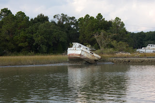
Price Creek, SC 32º54.119N | 75º40.277W
 |
| Our two neighbors at Price Creek. |
 |
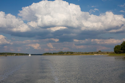
| Attempting the impossible: capturing the scene. |
 |
| Yes, a rainbow. |


Oy. Run-call-yer-mama low tide. Another stellar post, with more amazing pics. Kudos. <3
ReplyDeleteI remember anchoring in Oyster Creek, a little offshoot from the ICW. I think it was in lower S. Carolina. We anchored in some pretty good water at the mouth of the creek, but were awakened in the middle of the night by the boat listing. We got up and could tell the keel was on the bottom, and, apparently, the tide had a long way to go before it turned. By the time it did, we were all the way over, sitting in the cockpit with our feet braced against the downhill seat to keep from sliding out! Then, when we tried to leave in the morning on good tide, the engine started, then died. Fuel had drained out of the line during the severe heel, so I had my first experience at bleeding the lines! Tides are fun!
ReplyDeleteJohn Stubbings
It is so awesome to follow along on such a wonderful journey Tammy. You and Chip must be having a blast. Carolyn and I are watching through your journaling and wishing to do something similar. What a trek!
ReplyDeleteChuck
Thanks, John, H.
ReplyDeleteJohn S., Wow, I'm not sure I would call that fun. I'm glad there's a happy ending!
CHUCK! Thanks for following along. You and Carolyn just come on down!